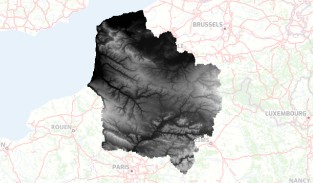
Modèle numérique de terrain des Hauts-de-France
Modèle numérique de terrain (MNT) maillé (1 m) qui décrit le relief du territoire de la région Hauts-de-France à grande échelle.
default-legacy
- Date (Creation)
- 2022-12-01
- Citation identifier
- https://www.geo2france.fr/relief/regalti1m
- Point of contact
-
Organisation name Individual name Electronic mail address Role Géo2France
Géo2France
Point of contact
- Maintenance and update frequency
- Not planned
-
GEMET - INSPIRE themes, version 1.0
-
-
Altitude
-
-
Région
-
-
HAUTS-DE-FRANCE
-
-
Départements
-
-
AISNE
-
SOMME
-
OISE
-
NORD
-
PAS-DE-CALAIS
-
- Theme
-
-
DONNEES OUVERTES
-
MNT
-
RELIEF
-
RTGE
-
SPRD
-
- Use limitation
-
Utilisation libre sous réserve de mentionner la source (a minima le nom du producteur) et la date de sa dernière mise à jour
- Use limitation
-
Données ouvertes
- Spatial representation type
- Grid
- Distance
- 1 m
- Denominator
- 10
- Language
-
fre
- Character set
- UTF8
- Topic category
-
- Imagery base maps earth cover
- Description
-
France
- Description
-
HAUTS-DE-FRANCE
))
- OnLine resource
-
Protocol Linkage Name OGC:WMS
https://www.geo2france.fr/geoserver/geo2france/ows RGEALTI_MNT_1M_LAMB93_HdF
OGC:WMS
https://www.geo2france.fr/geoserver/geo2france/ows RGEALTI_hillshade_regular_semitransparent_1M_LAMB93_HdF_cog_bilinear
WWW:LINK-1.0-http--link
https://geoservices.ign.fr/rgealti Site web IGN
- Hierarchy level
- Dataset
Conformance result
- Date (Publication)
- 2000-01-01
- Explanation
-
-- Information sur l'évaluation de la conformité (non INSPIRE) --
- Pass
- Statement
-
Donnée basée sur le RGE ALTI 1M de l'IGN.
Metadata
- File identifier
- 36d1780e-bcfd-453f-947a-bb315c389220 XML
- Metadata language
- Français
- Character set
- UTF8
- Hierarchy level
- Dataset
- Hierarchy level name
-
Précision sur le niveau de hiérarchie (non INSPIRE)
- Date stamp
- 2025-02-28T15:23:55.741349Z
- Metadata standard name
-
ISO 19115:2003/19139
- Metadata standard version
-
1.0
- Metadata author
-
Organisation name Individual name Electronic mail address Role Géo2France
Géo2France
Point of contact
Overviews
Spatial extent
Provided by
