 Géo2France
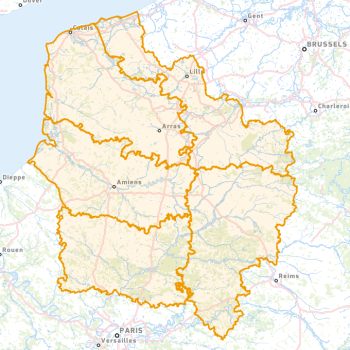
Limites des départements
Limites des départements de la région Hauts-de-France, basée sur la donnée Admin Express de l'IGN (millésime octobre 2020)
default-legacy
- Date (Publication)
- 2020-10-01
- Citation identifier
- https://www.geo2france.fr/departements
- Point of contact
-
Organisation name Individual name Electronic mail address Role IGN-F
Author
-
GEMET - INSPIRE themes, version 1.0
-
-
Unités statistiques
-
- Keywords
-
-
SPLD
-
DEPARTEMENT
-
IGN
-
-
Départements
-
-
AISNE
-
PAS-DE-CALAIS
-
NORD
-
OISE
-
SOMME
-
-
Région
-
-
HAUTS-DE-FRANCE
-
- Access constraints
- Other restrictions
- Other constraints
-
Pas de restriction d’accès public selon INSPIRE
- Spatial representation type
- Vector
- Denominator
- 5000
- Language
- Français
- Character set
- UTF8
- Topic category
-
- Boundaries
N
S
E
W
))
- Reference system identifier
- urn:ogc:def:crs:EPSG:2154
- Geometric object type
- Surface
- Distribution format
-
Name Version ESRI Shapefile
1.0
- OnLine resource
-
Protocol Linkage Name OGC:WFS
https://www.geo2france.fr/geoserver/spld/ows spld:DEPARTEMENT
OGC:WMS
https://www.geo2france.fr/geoserver/spld/ows DEPARTEMENT
- Hierarchy level
- Dataset
Quantitative result
- Value
- Consistency has not been evaluated
- Statement
-
Admin Express IGN
Metadata
- File identifier
- a8591404-c2f7-4080-87c4-266e9582a26f XML
- Metadata language
- Français
- Character set
- UTF8
- Hierarchy level
- Dataset
- Date stamp
- 2020-12-07T14:46:18
- Metadata standard name
-
ISO 19115 Geographic Information - Resource
- Metadata standard version
-
2003/Cor.1:2006
- Metadata author
-
Organisation name Individual name Electronic mail address Role Géo2France
contact@geo2france.fr
Point of contact
Overviews
Spatial extent
N
S
E
W
Provided by

Associated resources
Not available