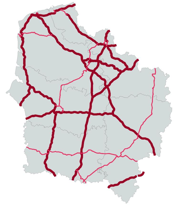
Réseau routier principal (autoroutes et nationales) (SRADDET 2020-08) - SRADDET 2020
Tracé du réseau des autoroutes et routes nationales des Hauts de France.
Cette donnée est la représentation figée à la date de vote du SRADDET (approuvé par arrêté préfectoral le 4 août 2020)
default-legacy
- Date (Creation)
- 2020-11-03
- Citation identifier
- fr-200053742/2019/srradet/transp_reseau_routier
- Status
- Completed
- Point of contact
-
Organisation name Individual name Electronic mail address Role Région Hauts-de-France
Point of contact
- Maintenance and update frequency
- As needed
- Keywords
-
-
SCHEMA REGIONAL D'AMENAGEMENT DE DEVELOPPEMENT DURABLE ET D'EGALITE DES TERRITOIRES
-
SRADDET
-
INFRASTRUCTURE
-
RESEAU ROUTIER
-
POLITIQUE REGIONALE
-
AMENAGEMENT DU TERRITOIRE
-
AUTOROUTE
-
ROUTE NATIONALE
-
TRANSPORT ROUTIER
-
DONNEE OUVERTE
-
-
Thèmes - SIG - HdF
-
-
TRANSPORT
-
-
GEMET - INSPIRE themes, version 1.0
-
-
Réseaux de transport
-
-
Région
-
-
HAUTS-DE-FRANCE
-
-
Départements
-
-
PAS-DE-CALAIS
-
OISE
-
NORD
-
AISNE
-
SOMME
-
- Use limitation
-
Utilisation libre sous réserve de mentionner la source (a minima le nom du producteur) et la date de sa dernière mise à jour
- Use limitation
-
Données ouvertes
- Use constraints
- Other restrictions
Spatial resolution
- Denominator
- 150000
Spatial resolution
- Language
-
fre
- Character set
- UTF8
- Topic category
-
- Transportation
))
- Distributor contact
-
Organisation name Individual name Electronic mail address Role Conseil régional Hauts-de-France
Point of contact
- OnLine resource
-
Protocol Linkage Name WWW:LINK-1.0-http--link
https://sig.hautsdefrance.fr/ext/opendata/Sraddet2020/transp_reseau_routier.csv Tableau de données transp_reseau_routier
OGC:WMS
https://qgisserver.hautsdefrance.fr/cgi-bin/qgis_mapserv.fcgi?MAP=/var/www/data/qgis/applications/sraddet_2020_08.qgz transp_reseau_routier
OGC:WFS
https://qgisserver.hautsdefrance.fr/cgi-bin/qgis_mapserv.fcgi?MAP=/var/www/data/qgis/applications/sraddet_2020_08.qgz transp_reseau_routier
WWW:LINK-1.0-http--link
https://sig.hautsdefrance.fr/ext/opendata/Sraddet2020/transp_reseau_routier.zip Shapefile transp_reseau_routier
- Hierarchy level
- Dataset
Conformance result
- Date (Publication)
- 2020-11-10
- Explanation
-
-- Information sur l'évaluation de la conformité (non INSPIRE) --
- Pass
- Statement
-
IGN BD Topo 2016
Donnée figée à la date de vote du SRADDET (approuvé par arrêté préfectoral le 4 août 2020)
Metadata
- File identifier
- b887ef25-cf8c-4b66-9eda-08d5331709cc XML
- Metadata language
- Français
- Character set
- UTF8
- Hierarchy level
- Dataset
- Hierarchy level name
-
Précision sur le niveau de hiérarchie (non INSPIRE)
- Date stamp
- 2024-12-08T21:35:27.462095Z
- Metadata standard name
-
ISO 19115:2003/19139
- Metadata standard version
-
1.0
- Metadata author
-
Organisation name Individual name Electronic mail address Role Région Hauts-de-France
Point of contact
Overviews
Spatial extent
Provided by